

技術開発賞
Outstanding Civil Engineering Achievement Award
2010年(平成21年度)
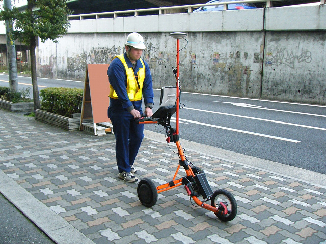
電磁誘導法を利用した地下埋設物連続探査システムの開発
Development of a system for continuous exploration of buried object using the electromagnetic induction method.
- 福田 和弘 (NTTインフラネット(株)),福井 豊一 (NTTインフラネット(株)),本藤 聡一郎(NTTインフラネット(株))
- Kazuhiro Fukuda (NTT Infrastructure Network Corp.), Toyokazu Fukui (NTT Infrastructure Network Corp.), Soichiro Hondo (NTT Infrastructure Network Corp.)
| 概要 | Summary |
|---|---|
|
地下埋設物連続探査システムは、道路下に埋設されたライフライン設備を「連続的」かつ「高精度」に探査できるシステムである。通信ケーブルや水道管等約560kmの探査実績を有し、道路掘削工事等による損傷事故防止等を目的とした設備管理技術として活用されている。 本システムは「位相評価」と「磁界分布解析」という新たな概念を取り入れ、従来困難であった埋設物が輻輳する箇所での探査を可能とした。また、カート型受信器を走査し、埋設物の水平位置と深度を同時に連続的に測定することで、線形が変化する箇所を迅速に把握すると同時に、作業時間を従来の10分の1程度に短縮し、大幅なコスト削減と、道路規制に伴う渋滞の緩和を可能とした。 測定データはGISとの連携による効果的な設備管理を実現するとともに、地理空間情報基盤の構築につながるものとして期待されている。 |
The continuous exploration system can survey underground lifeline facilities with high accuracy. It has been used for exploration of 560 km of telecommunication cables and water pipes for the purpose of avoiding accidents by excavating works on roads. It made possible to survey in the dense area of underground facilities by developing such concepts as "phase evaluation" and "electromagnetic distribution analysis". The system can survey horizontal and vertical location of an underground facility at a time, and significantly reduce the time and cost. Measurement data linked to GIS provides an effective facility management. |